Inangahua and Murchison are synonymous with earthquakes and there is certainly plenty of evidence to be seen.
 |
| A photo from the internet as our camera batteries went flat!! |
 |
| Evidence of the 18million cubic metres of soil and rock dislodged. |
We spent a couple of days in Murchison and the local museum is an excellent source of information about how the quakes both affected the landscape and the lives of the people living there. One of the walks we chose to do (recommended by my cousin Stewart who lives there) was the Johnson Creek Walk. A drive 6km along the west bank of the Matakitaki River takes you to the start of this 2.4km walk. The track initially takes you through beech forest and along the side of the creek as it winds its way upwards. As you come out of the bush the landscape changes dramatically and you could think you were in a moonscape with low scrub. It has been caused by a huge landslide caused by the June 17, 1929 Murchison Earthquake (7.8). Enormous pieces of rock, sand and dirt are lying below the rock faces hundreds of metres above where they let go over 80 years ago. This track is not well publicised and although it is well formed it is not well worn. We certainly never saw anyone else, just a few wild goats!
 Driving from Murchison to Springs Junction yesterday we stopped off at the Maruia Falls, about 15km south of Murchison. This waterfall on the Maruia River is a result of the 1929 Murchison Earthquake. Usually it is an upthrust that causes waterfalls like this but this one is different as the entry in the Te Ara Encyclopedia explains:
‘The Murchison earthquake of 1929 produced the Maruia Falls through a different process – a landslide in the Maruia Valley, shown by the dotted lines. This diverted the course of the Maruia River further west, forcing it to cut a new channel over an old river bank. Once the river had eroded the gravels, the bank became the Maruia Falls.’ They are very spectacular even with this dry spell of weather.
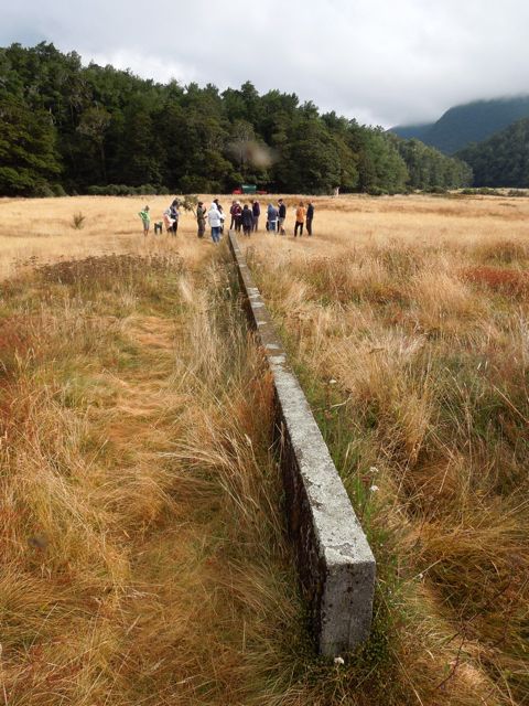
Our camp for the night was right on the Alpine Fault line just east of Springs Junction. It was another DOC camp and was well laid out with plenty of good camping spots, water and toilets. When we went off for our walk this morning we found earthquake monitoring equipment in the form of a 24 metre wall. This was installed in 1964 right through the middle of the fault to observe any movement in the fault line. It is interesting that to date no such movement has been recorded so even the 1968 Inangahua quake didn’t cause a shift. It is now thought that the plates don’t make small movements but instead make sudden large movements which is typical of all active faults in NZ and around the world. Studies indicate that last movement was probably in the 1660s and it caused the two edges of the fault to move 1.3m horizontally and 0.25m vertically. We are making assumptions that this a popular site for any students or researchers interested in Earthquakes and their effects as even in the short time we were there, a group of 16 German students were visiting it as part of a field trip.

No comments:
Post a Comment